 |
Cocklebiddy WA 6443 |
| Population: 80, Height above sea level: 20m Latitude: -32.2242 Longitude: 126.5467 Location: 1,165km east of Perth Highway: Eyre Hwy (1) Nearest Major Town: Perth 1160 W Nearest Airport: Ceduna Touring Area: Goldfields - Esperance | |
|
Roadside stop on the Eyre Hwy in eastern, Western Australia. Established as an
Aboriginal Mission Station (now only ruins), then a repeater station on the Adelaide to Perth Telegraph Line,
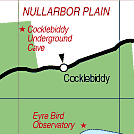
the roadhouse is now a popular stop along the highway. The telegraph station 50km south on the Great Australian Bight is now a Bird Sanctuary and observatory in the Nuytsland Nature Reserve. Over 230 species have been recorded there. To the west the Cocklebiddy Caves are the world's longest navigable underground caves and a challenge for divers. The current record dive is over 6km. | |
 |
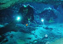 Divers in Cocklebiddy Cave. |
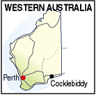
| To see a map of the town, click on the top map, for a map of the area, click on the bottom map, for more information about the town, click on the photograph. | |
 |
© Copyright Peter W. Wilkins | |