 |
Dalwallinu WA 6609 |
| Population: 600, Height above sea level: 340m Latitude: -30.2700, Longitude: 116.6400 Location: 250km north east of Perth Highway: Great Northern Hwy Nearest Major Town: Perth Nearest Airport: Perth Touring Area: The Wheatbelt | |
|
Sheep and grain producing area north east of Perth. It began as a station on the railway line between Mullewa and Wongan Hills and was gazetted as a town in 1914. Benedictine monks from New Norcia grazed sheep on the nearby pastoral leases they had taken up and the first settlers followed in 1907 to develop the lands for cropping. In 1910 it was opened for selection and first crops were planted shortly after. | |
 |
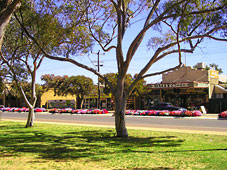 |
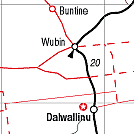
| To see a map of the town, click on the top map, for a map of the area, click on the bottom map, for more information about the town, click on the photograph. | |
 |
© Copyright Peter W. Wilkins | |