 |
Kambalda WA 6442 |
| Population: 2,700, Height above sea level: 60m Latitude: 31.09.00, Longitude: 121.35.00 Location: 620km east of Perth Highway: Great Eastern Hwy then Coolgardie - Esperance Hwy Nearest Major Town: Kalgoorlie Nearest Airport: Kalgoorlie Touring Area: Goldfields - Esperance | |
|
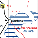
Gold was discovered at Kambalda in 1896 by Percy Larkin and a town was gazetted
in 1897 as mining began at the Red Hill Gold Mine. Within a decade the gold had run out
and Kambalda became a ghost town until 1954 when nickel was found. Australia's first nickel mine followed and the town split into Kambalda West and East, some 4km apart and of different origins. Kambalda West is the residential and touring region while the east is where the mine is. Places to visit include the Red Hill Lookout and walking trail, the Memorial Garden and Wall at the Shire offices, and Lake Lefroy, a 510 sq km salt pan where land yachts can be seen. Kambalda West has a supermarket, hotel, and recreation centre along with other general businesses. There is also an airstrip with flights to and from Perth. | |
 |
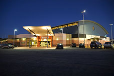 Kambalda West Recreation Centre |


© Copyright Peter W. Wilkins