 |
Narrogin WA 6312 |
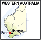
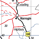
| Population: 4750, Height above sea level: 190m Latitude: -32.9610, Longitude: 117.1100 Location: 190km south east ofPerth Highway: Great Southern Hwy, east at William or Great Southern Hwy Nearest Major Town: Perth Nearest Airport: Perth Touring Area: WA - Wheatbelt | |
|
Grazing and grain growing centre south east of Perth.
Alfred Hillman and his party surveyed the track between Perth and Albany in 1835 and
passed only 10 km west of the present site of Narrogin.
They were followed by shepherds searching for good pastures, and pastoralists who
took up land in the 1860s and 70s. It was gazetted as a town in 1897. The settlement struggled until the railway arrived in 1889 and produce could be more easily shipped to Perth. Places to visit include the old Courthouse Museum and the Nexis Gallery and Arts Space, and the Foxes Lair Nature Reserve. There are motels, hotels, caravan park, B&Bs and Farm Stays. | |
 |
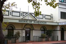 Council offices in Narrogin |


© Copyright Peter W. Wilkins