 |
Pemberton WA 6260 |
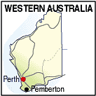
| Population: 800, Height above sea level: 175m Latitude: -34.2700, Longitude: 116.0200 Location: 335km south of Perth Highway: South Western Hwy Nearest Major Town: Bunbury Nearest Airport: Albany Touring Area: South West | |
|
Surrounded by karri forests, Pemberton offers enchanting forest walks,
scenic drives, canoeing, fishing and horse-riding.
The Beedelup Falls are nearby (18km) and accessible by wheelchair. The Pemberton Tramway Company operates a light rail service between Pemberton and Lyall and there is a locomotive display. Nearby, the Gloucester National Park features the Gloucester Tree, a climbable tree of over 60 metres for the adventurous to scale. Two others in the park are the Diamond Tree and the Dave Evans Bicentennial Tree. Until 2005 sawmilling was the main industry but now the concentration is more on tourism. Pemberton is on the Bibbulum Walking Track and activities include river cruises, 4WD tours, hiking and canoeing. There are 5 national parks within an half hour of Pemberton and festivals include the Southern Forests Festival held over three days in May. There are also several cool climate wineries in the area, and the Big Brook dam and Beedalup Falls are popular places to visit. | |
 |
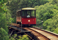 The Pemberton Tramway is a local tourist railway. |
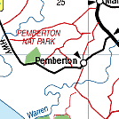
| To see a map of the town, click on the top map, for a map of the area, click on the bottom map, for more information about the town, click on the photograph. | |
 |
© Copyright Peter W. Wilkins | |