 |
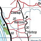
Waroona WA 6215 |
| Population: 2,150, Height above sea level: , Latitude: 32.5200, Longitude: 115.5500 Location: 110km south of Perth Highway: South Western Hwy Nearest Major Town: Bunbury Nearest Airport: Perth Touring Area: WA - Peel | |
|
On the highway between Bunbury and Pinjarra in the shadow of the Darling Range,
Waroona is a farming and mining area. Bushwalking, swimming. It was originally called Drakesbrook, after William Henry Drake, an Assistant Commissioner General and original landholder in the area. It was first settled by John Fouracre in 1891. In 1895 Joseph McDowell built a timber mill at the present-day Mill Street, when a railway siding was opened New, and more popular, lots were surveyed near the mill, which became known as Waroona. | |
 |
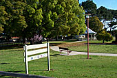 Drakesbrook Park at waroona |


© Copyright Peter W. Wilkins