| DALBY - QUEENSLAND - 4403 | ||||
|---|---|---|---|---|
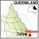 |
Population: 10,000, Latitude: -27.1300 Longitude: 151.2000 Location: 220km west of Brisbane Highway: Warrego and Bunya Hwys Nearest Major Town: Nearest Airport: Touring Area: Toowoomba & Golden West |
 |
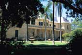 Jimbour House - Dalby - Courtesy of Tourism Queensland | |
 | ||||
|
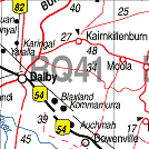
Dalby is in the Darling Downs region of Queensland, approximately 210 kilometres
(130 miles) west of Brisbane, at the junction of the Warrego, Moonie
and Bunya Highways. It was founded in the early 1840s at a place known locally as
"The Crossing" on Myall Creek and is the administrative centre of the Western Downs
Region and the centre of Australia's richest grain and cotton growing area. The name of the town is believed to come from the village of Dalby on the Isle of Man and was chosen by Captain Samuel Perry when he surveyed the settlement in 1853 to reflect immigration from there in the mid nineteenth century. Dalby was linked by rail to Ipswich on 20 April 1868. ,br> On fertile black volcanic soil it lies in the shadow of the beautiful Bunya Mountains near the Concomine River. The soldier re-settlement programme following World War 2 established the population for expansion of its agricultural foundations and assured its growth. An obelisk at The Crossing in Edward Street marks a spot where explorer Henry Dennis camped beside Myall Creek in 1841. PLACES OF INTEREST: Contains historic buildings and displays from pioneering days. Blacksmith shop. machinery shed, cottage, etc. mineral and fir-earms display. ACCOMMODATION & SERVICES: 
|


© Copyright Peter W. Wilkins