| ELIZABETH TOWN - TASMANIA - 7304 | ||||
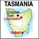 |
Population: 500, Elevation: 40m Latitude: -41.2752 Longitude: 146.3343 Location: 220km north west of Hobart, 50km west of Launceston Highway: Bass Hwy Nearest Major Town: Deloraine Nearest Airport: Launceston Touring Area: Great Western Tiers |
 |
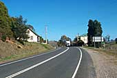 On the Bass Highway at Elizabeth Town. | |
 | ||||
|
The old Elizabeth Town Pub was a popular stop-over along the road between Launceston and Devonport
and has now been converted and upgraded as a coffee house which is gaining increasing trade for
travellers to and from the Spirit of Tasmania. At the heart of a productive agricultural region producing dairy products and small fruits, and near pine forests, it is an attractive place to stop and visit. From Elizabeth Town the road also leads to Sheffield and Mole Creek which opens up the Cradle Mountain region and the Central Highlands. Just east of the small township is Christmas Hills Raspberry Farm and Cafe where you can pick your own raspberries and purchase fresh raspberry products in season. To the south is the Trowunna Wildlife Park, featuring indigenous animals, especially the Tasmanian Devil.
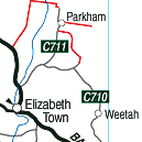
INFORMATION CENTRE: Great Western Tiers Visitor Centre Emu Bay Rd, Deloraine. Tasmania. 7304 HOW TO GET THERE: By car along the Bass Hwy, east from Devonport or West from Launceston. The Lakes Hwy from Melton Mowbray in the south terminates in Deloraine and provides an alternative scenic way to reach Elizabeth Town from Hobart. Parts of the road around the Great Lake are loose surface and work on upgrading this highway is costantly in progress. Coach Operators Redline: Ph: 1300 360 000 Greyhound Pioneer: 132 030 | ||||||||

 |
© Copyright Peter W. Wilkins | |