|
Wilkins Tourist Maps produces a free map in this area. You can pick up a Derwent Valley map from accommodation houses, attractions and businesses, and some information centres in towns in this area. Click here for names and addresses of outlets where they are available. Select an area from below to automatically open it on this page.
|


|
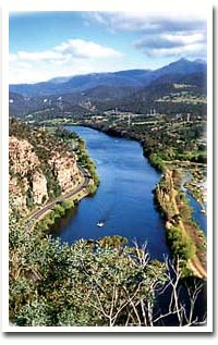
THE DERWENT VALLEY A drive along the scenic Derwent River The Derwent Valley is one of Australia's most scenic areas. The river rises in the Central Highlands at Lake St Clair and flows through a dozen of so towns before meeting the ocean at Hobart where it joins the harbour. Lined with exotic trees like willows and elms, it is a riot of colour in Autumn and it is nearly impossible to take a photograph which is not outstanding. The small towns along the river produce a large variety of produce including hops, berries, vegetables and grapes. There are several wineries in the region. The largest town is New Norfolk which has many historic buildings including the Bush Inn, Australia's oldest hotel
and the interesting Oast House, a collection of craft and food stores in an old hop oast just east of the highway
as you enter New Norfolk from Hobart. The pretty town of Westerway has accommodation, general store and petrol, and is a popular centre for touring. In the northern section of the area are the historic towns of Hamilton, Bothwell and Ouse where there are dozens of historic buildings, old churches (Australia's oldest Anglican Church is in Hamilton), galleries and museums, inviting cafes and coffee lounges, and unique attractions like the Australian Golf Museum at Bothwell. As you head further west from Ouse you enter the central highlands and the heart of Tasmania's massive Hydro-electric system. Power stations at Waddamana, Wayatinah, Tungatunah and Tarraleah will be seen, connected by deep fast flowing channels between a system of lakes. At Tarraleah the view down the massive pipe spillway is spectacular. The head of the river at near Derwent Bridge where there is a timber gallery and, just north, the beautiful
Lake St Clair and an interpretive centre and facilities for accommodation and campers. A special 10 day tour brochure will be found elsewhere on this site and includes tours to all parts of Tasmania. |
FLASH FILE:
Hold down ALT (PC) or CONTROL (Mac) and click on image to zoom. Drag to navigate.
DERWENT VALLEY TOWNS
Bothwell
Bushy Park
Derwent Bridge
Ellendale
Fentonbury
Gretna
Hamilton
New Norfolk
Ouse
Strathgordon
Tungatinah
Westerway
DERWENT VALLEY ATTRACTIONS
The Bush Inn
Salmon Ponds
Mt Field National Park
Lake St Clair
Bothwell Golf Museum