|
Wilkins Tourist Maps produces a free map in this area. You can pick up a North East map from accommodation houses, attractions and businesses, and some information centres in towns in this area. Click here for names and addresses of outlets where they are available. Select an area from below to automatically open it on this page.
|


|
THE NORTH EAST & FLINDERS ISLAND A drive along the scenic Derwent River The North East of Tasmania is a mix of dense rainforest in the south, the Blue Tier range with extensive walks in the centre, and the beaches and plains of the northern coast. It also includes the 70 or so islands of the Furneaux Group including Flinders and Cape Barren Islands. Flinders Island is dealt with by itself in this guide. Heading east from George Town on the Tamar Valley Tour the first stop in the north east is Bridport. A small fishing town on Andersons Bay, it is a popular holiday destination for Tasmanians and visitors and several large resorts provide accommodation. Fresh fish can be bought at the wharf and Bridport is the port for travellers by boat or charter plane to Flinders Island. From Bridport head south to Scottsdale and the Forestry Centre and get some information
on what to see and do in the area. To the east you get into forest country. large stands of old growth forest will
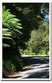
be seen from Branxholm on with the road winding through and providing exhilarating contact with nature. The Weldborough
Pass Walk takes you into the forest and further on, from the turn-off to Goulds Country, is a loose surface road
leading to the peak of the Blue Tier through large ferns and trees to the walks which lead from the summit. To the north, east of Bridport instead of heading south to Scottsdale are the small coastal towns of Tomahawk, Boobyalla and
Musselroe Bay. popular getaway destinations and fishing spots in a protected area along the Bass Strait coast. The north east offers a wide variety of attractions from forestry to mining and has extensive beaches and rugged coastline. It joins the Tamar Valley and Launceston sections to the west and the East Coast North to the south. Make sure you allow some time to explore it on your visit. |
FLASH FILE:
Hold down ALT (PC) or CONTROL (Mac) and click on image to zoom. Drag to navigate.
Click on a town for more.
THE JOURNEY THERE
Scottsdale
Bridport
Branxholm
Pyengana
Gladstone
Derby
Legerwood
Herrick
Moorina
Tomahawk
Ansons Bay
Goulds Country
Jetsonville
Blumont
Click on an attraction for more.
St Columba Falls
The Blue Tier
Eddystone Light
Mt William National Park
Weldborough Pass