|
|
|
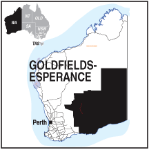
GOLDFIELDS - ESPERANCE AREA OF WESTERN AUSTRALIA
The Goldfields-Esperance region is the largest of Western Australia's tour regions, with an area of
770,488 square kilometres divided into three distinct sections. In the south the Esperance region is coastal
running along, and in from, the Great Australian Bight with sandy beaches between towering cliffs and open to
the Southern Ocean. There are ports and seaside villages and lowland national parks.
In the centre around Kalgoorlie some of the world's richest gold deposits were found, some of them
are still mined along with other rich resources like nickel and uranium. Here you will find exciting
mining towns. Fabulous buildings built during the height of the mining boom reflect the wealth which
was extracted.
To the far north and east are the arid regions of the Nullarbor Plain and Great Sandy Desert. Smaller towns,
much more remote, dot the barren landscape. Some still work as mining towns but most have retired to reflect
on times past. In this region remote aboriginal communities make their home holding on to the land of
their forefathers and observing the customs and rituals of a depleted nation. The entire population of
aboriginal people remaining in Australia would barely fill a city like Geelong. Full blood
aboriginals would fit into Wagga Wagga or Toowoomba.
Away from Esperance and the coast, where reliable winter rainfall is usually around 700mm a year, it is mainly
a low, flat plateau with poor soil, no rivers, high salinity and unsuitable for stock. Elsewhere the average rainfall
is around 250mm which is quickly absorbed by native plants and evaporation creates large salt pans.
The climate is mostly hot and dry with the Little Sandy Desert and the Gibson Desert in the northern part of the
region and the Great Victoria Desert in the south east.
The whole region has a population of under 60,000, with nearly half living in Kalgoorlie-Boulder and a quarter
in the Shire of Esperance; the remaining shires are sparsely populated with around 10% of Aboriginal descent.
The economy is based on mineral resources, primarily gold and nickel with some uraniun deposits.
In 2012 the mining of gold, nickel and platinum yielded just under A$9 billion.
Around Esperance, wheat, canola and barley is widely grown and produces about 80% of the areas agricultural
economy. Sheep and cattle stations are common in the area although stocking levels are meagre. Coastal fishing and
aquaculture fisheries for abalone, pilchards and sharks will be found along the coastal fringe.
Tourism is a major feature and Esperance and the surrounding national parks are an important contributor to
the local economy in the south, and the city of Kalgoorlie Boulder in the north.
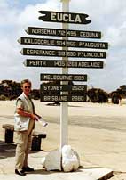
Vast distances separate many of the towns along the way and much of the traffic across the Nullarbor plain
consists of large semi-trailers carrying freight to and from Perth.
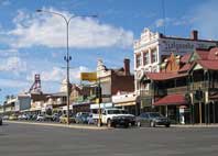
Kalgoorlie - Boulder and the Goldfields
The name Kalgoorlie comes from the Wangai word Karlkurla, meaning "place of the silky pears".
Mining (mostly gold and nickel) and the related service industries dominate the regional economy.
Supplementing that is the agricultural industry of mainly cereal, wool and livestock production,
tourism and commercial fishing.
Kalgoorlie is one of Australia's best known and colourful towns.
In 1893 Paddy Hannon found gold here which created a gold rush to the middle of the desert. Gold is
still mined today and a thriving city has been created around it.
There are still a large number of impressive buildings to be seen in this historic town and
several museums explaining the development of the Kalgoorlie-Boulder area.
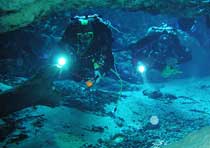
Underground tours of some of the mines are available and the 'Golden Mile' lookout gives panoramic
views over the city.
Kalgoorlie is also noted for its "two-up" schools and the legalised brothels which are reminiscent of
the days when it was a hard frontier town with few women.
PLACES OF INTEREST:
Mine Tours
Historic pubs and buildings
Golden Mile Lookout
Two Up Schools
Gold Fossicking
SERVICES:
INFORMATION CENTRE:
Kalgoorlie Goldfields Information Centre
250 Hannon St. Kalgoorlie. WA 6430
Ph: 08 9021 1966
Goldfields Information Centre
106 Burt St. Boulder WA 6430
Ph: 08 9093 1083
HOW TO GET THERE:
By car along the Great Eastern Hwy. turn off at Coolgardie onto Goldfields Hwy.
Airport, road, transcontinental rail
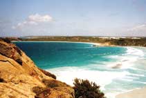
Esperance and the Cape le Grande National Park
Esperance is where the Coolgardie - Esperance Hwy meets the coast and the Southern Ocean and leads west
along the Great Southern Hwy and on to Perth. With a population of around 10,000 it is a popular stop-over
for travellers from the Nullarbor Plain and has beaches, plenty of accommodation, and a good shopping centre.
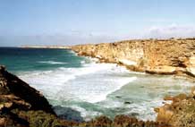
To the east the 31,800 Ha. Cape le Grande National Park is named after one of the officers on the French ship
l'Esperance' captained by Admiral Bruni d'Entrecasteaux, the first European to sight the area.
It has a wide variety of scenery including beaches, sand-dunes, coastal cliffs and
offshore islands.
There are 4 other national parks in the area and the famous Wave Rock
is located to the north west.
There are wineries at Dalyup and Condingup and a visit to the Municipal Museum at the
visitor centre will give you plenty of ideas on what to see and do.
INFORMATION CENTRE:
Esperance Tourist Bureau
Museum Village, Dempster St. Esperance. W.A. 6450
Ph: 08 9083 1555. Fax: 08 9071 4543
Email: bookings@visitesperance.com
www.visitesperance.com
|
|
 MAPS
MAPS
